Paddle: Elbow River, Glenmore res to Bow River. Alberta
Quick Summary
Summary: Short 1.5hr paddle through the city of
Calgary.
Date of trip: Oct 19, 2004
Distance of trip: est 5 km, 1 - 1.5hrs
How to get to the set in point: East off crow child
trail on 50th street, follow to very end of road.
Take out: NOrmally the Zoo, but bridge is closed,
alternate is just accross the elbow from the Ft. Calgary
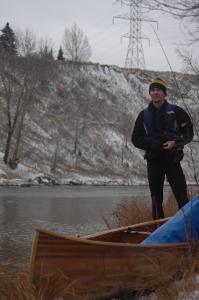
Paddleiing partners: Rich B.
Level of experince of group: Novice+
Camp sites used: NA
Weather Conditions: Cloudy, -4Deg C High for the day
Trip rating, and some justification of the rating:
Good. For a paddle right through the city this is a very nice trip.
Only once for a short distance, did we really notice traffic
running parallel to the river. Mostly through parks, and along back
yards
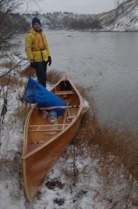
Boat style used: Strip build Huron Cruiser
|
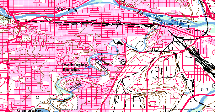
"Map is © Her Majesty the Queen in Right of Canada,
Department of Natural Resources. All rights reserved."
map from the website http://toporama.cits.rncan.gc.ca/toporama_en.html
|
On with the paddle
Yesterday walking through the snow, on our way back from lunch
to work, I commented to my
buddy/co-worker Richard that it would be really nice to be out paddling
in it. He agreed. I asked if he would be in for an after work
paddle the next day... he was "100% in".
Next morning I, scraped off the car, shoveled the snow,
loaded the canoe on top of the car, and went to work.
Walking into the door I got the first comment,
"your not going paddling
today are you?!", asked in shocked surprise. "Maybe, if there
is still enough water being
my answer. If some one does not 'get it' chances are it
is not worth explaining to them. I was however, surpised to get
similar questions from James and Jason, two that have
recently taken up paddling. Funny thing is I'm sure if I
suggested going skiing in -15 Degree weather they'd be ready
to go. Today
it is forcast for a high of -4 Deg C. Not exactly hot, but
not cold either, and it's not going to to be warmer for some
time. It's been a wet summer, so maybe there is enough water
flowing to make it down the Elbow River, a small river running
through town.
3:00 rolled around and right on time Rich was telling me
was heading home, to dig up his paddling cloths. I follow and meet
him at his place, and drop off his car at the take out just
down the road where the Elbow meets the Bow.
It's around 4:30 by the time we get to the set in. There
is one other car in the parking lot. Other wise the park is
deserted, only a few tracks in the snow from yesterday.
After unloading the kayak, and setting all the gear into it
we walk down to the river to look at the set in. The river is low,
but it is not clear that is is all that much lower than the last
(and first) time we were down this section.
That time we managed to make the trip
without hitting bottom once. Kind of an accomplishment as the river is
often shallow. Doing the same today, will be much more
of an accomplishment.
The set in point is shallow, maybe an inch, the channel is on the
other side of the river. We scout down stream, then upstream for a
better access. Upstream looks promising. Lugging the canoe down the
hill from
the parking, on the narrow some what trecherous snow covered foot path
to the set in goes without either of us landing on out butts. Although
once it was close for me.
we set the canoe parallel to the bank, pointing up stream. Neither of us brought our boot, and
neither are keen to step in the 0 Deg C water. It is about 3-4 inches deep, very
questionable if it will float us. We both climb into the canoe, and we
are resting on the bottom. I guess it was not that
firmly stuck, as we pushed out to the just deep enough water a foot or so
from shore, the sounds of the bottom scraping is not to severe... but not
pleasant either.
That's it we are afloat, and we are able to cross to the channel.
The "Channel" in the river at this point
is about 13 inches deep, a few larger rocks in the bed coming up higher, but
not enough to abort the trip. This give us a fair bit of clearance for the
most part, although not
a lot of bite for the paddels. It does force us to pay attention to the
larger rocks in the river.
We are not far along before we pass under a foot bridge, just as a crazy
jogger is crossing it, we share a friendly wave. I wonder what she thought of
us. We are through the first shallow
section of the river, it slows a bit, deepens a bit (for a 100m or so).
I suggest Rich get a few picturs. He fumbles with the big dry bag behind
him, gets is fancy new SLR digital camera out. Takes a few pics and puts
it away. that the last of the pictures for the trip. To awkward getting
to it from behind the back.
The cause of the deepening part of the river is, as usual a bit of a
high spot in the river bed, sometimes a constriction in the flow,
backing the water up. It is obvious this one is the former, with Rocks
sticking out in the shallows, on the verge of forming an island. It is
not obvious which way is best. The difference between channel depth is
typically measured in inches, with only a few to spare.
And so it proceeds for the trip. Trying to pick the channels down the
river. We do pretty good for the most part. Chassing the geese and ducks
down the river. At one point we come to a group of 3 islands. we decide
to take the right hand path. As we get near Rich comments, "that duck is
walking, not swiming". A sure sign the river is not deep enough. We quickly
turn left, and power to the real channel on the left side.
As the river pinches between the last island, and the shore, it
picks up a bit of speed, most of the water has joined our channel, and it is
being constricted by the end of the island. There is an old (willow?) tree
out hanging over the river. Some one has cut the branches so they don't
droop down into the water.
they are a good 6-10 inches in diameter, and there are 4 or 5 of them. All
at just the right height to give some one a real headache
or knock them out of a canoe. The water pushes right into them. We are
able to exicute a bit of a side slip/ back ferry to miss them.
It's really nice paddleing with Rich. We've been friends for years, and
more or less started learning the canoing stuff together. We are now
at the point where our capability on this grade I river to navigate
between the obvious rocks and
hazards is pretty good. The rocks we do hit are where there are small
standing waves in a little riffle and we just did not see the rock. and the
difference of 2 inches between it and the bottom around it is enough to
hit it today.
One memorable incident occured when the river widened out and became
shallow
again. The River turns to the left initialy, then to the right about 200m
below. We are already on the left side and
decide to stay there as it looks 'deep enough', and there does not seem to
be many obstructions. It is shallow just in front of us, center and right
seem to have a fair number of rocks and stuff in the river.
River left results in a grinding halt as we hit bottom. It is about
2 inches deep, but the lack of current as it all goes left did not make
it all that obvious. As we were stopped, and not going anywhere, we discussed
our options. A man out walking the dog was fairly intently watching us.
Looking at us then the river, I assume wondering which path we would take, and
if we could possibly make it.
Obviously we need to be on the right side. Needing to stay right, and
transition back to the left before the river makes the bend. There
are several small rocks in the course, and one large one in the center of
the river, just off
to the side of the 'channel' as it crossed sides of the river. We
found our path, and made the canoe go mostly were we thought it should.
Only hitting bottom once or twice.
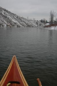
The Elbow is a small river, and today obviously shallow. In spots it
is several feet deep, but that is the exception. Being small, it is relativley
easy to bridge, we do float under a fair number of them. After the
second or so, there is an island. The chanel or river right is very small,
it is the channel we took last time, very enjoyable. I ask if we should
take it again, and am somewhat surprised when Rich says yes. The "Been there
done that" rule would suggest we take the other channel this time.
The channel pushes us past back yards, a couple of feet to
the right, and the more or less wild (considering it is in the middle of
the city) island a couple feet on the left.
The channel is not deep, has little room to move, but also has very
few obsticals, so we make it through without any trouble.
The river takes us near the Calgary stampede grounds.
At this point here is a small
island. Last time down we went Left, ended up (luckily) edding out, just
before being pushed over and ledge, or into a big rock just under the water.
All at a contriction right below the eddie. That time we were able
to paddle for all we were worth and make it up stream far enough to take
the right channel.
Today, with the river much lower, the decision to take the right channel
turns out to be the wrong one. The river is to shallow, and to many rocks
to make for easy progress. We back decide to see what the left side is like
in the lower water flow. we go down to our old friendly eddie.
As we approach the eddy, we go over a shallow gravel bar, just enough clearance
for the boat. Just enough clearence for three 16inch long fish that
dart up stream just
to the right of the canoe, with a burst of energy and a splash.
From the eddy we can see the Rock in the center of the constriction
is still there. But not nearly as imposing as last time. The current
is not as fast and furious today. It is not making a big splash as it
drives into the rock. On the left side of the rock is a 3-4 ft channel,
but it makes a "waterfall" type line just even with the rock. Looks
like a bit of a ledge. to the right side of the rock is what looks
like a 4ft channel, with a bit of fast water, a few rocks above,
and rocks scattered in the 40
ft or so down stream, as the two channels merge a few feet behind the rock.
That's our channel.
we execute a successful (at least partialy, and sure not very pretty)
back ferry out of the
eddy. Thank goodness we only had to go a few feet. The river would
surely have cranked us around if not. as it was we moved enough over,
that we could easily make it to the right of the rock. the angle was
less than Ideal, we were some what broad side to the current, with a
rock just above the big channel dividing rock. we poured on the steam,
to make it above the rock, and cranked a turn into the channel, missing
broad siding the rock at the stern by about 10 inche. Also, just missing
a third rock in fairly tight to the island (and for that matter the island)
with the bow of the canoe. that was it we are through the 'chute'.
A few less drastic manuvers take us through the rocks below as well, once
going between 3 rocks with only a few inches between to spare. Very satisfying
to make it through this section without a new scratch on my cedar strip canoe.
There are few simialar spots on this river. It is so small that tight
turning work at low flow is recommended. Before this trip, I'm not sure
I'd be confident Rich and I could have done as well as we did. By no means
are we goign to win style awards, and we have lots to learn, but it was very
gratifying being able to do as well as we did.
Now, this is not to say I do not have a dozen or so new scratches on
my canoe. I do, but nothing major, had we made this trip last year I suspect
I'd have some repair work to do. Even so this is considered a (knowlegable)
novice river, so that should put this in context.
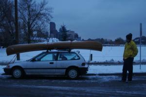
The last picture after loading the canoe on the car. We finish at
just the right time. This was one of the best paddles of the "summer"
for me. My feet
got a bit cold at times while kneeling, but nothing to bad. Once again
the decision to leave work early and go out was the right answer. My
only regret was not haveing a cell phone to call Jason and James let them
know what a great time they were missing.
[an error occurred while processing this directive]
Copyright Myrl Tanton 2004

