Trail Cafe: Trip report - Burstall Pass with Kids

Summary:

Download Waypoint, in GPX format (right click select "save as..." or 'download' as required)
Title: Burstall Pass with Kids
Trip type: hiking
Summary: A hike starts through the trees, passes through a upper alluvial plane, past glaciers, and then to just above the tree line (or at least almost) to a final lookout over the Spray river valley as you crest Burstall pass over the Spray Mountains.
Author: M. Tanton
Date of Trip: July 2015
Country: Canada (Assumed)
Province: Alberta
County/City/national park/etc: Kananaskis - Peter Lougheed prov. park
Location Route: Burstal Pass
Distance: 16km
Elevation Gain: 420 m
Weather Conditions:Good
Directions to Set in or Trail head: Trail head is about 39km South on the Smith-Dorrien trail from Canmore (gravel road). Alternate route is South from hwy 1 on Hwy 40, and back North on SD trail
Partners: Kaylyn (12yrs), Dana (8yrs)
Group experience level: novice
Author's Experience level: Intermediate
Authors Trip Rating: V. Good
Trip's Good Points: Nice Views of mountains, stream jumping
Trip's Bad Points: Stream may be difficult/dangerous in spring or after a rain


Trail Description:

Fantastic weather, hot at trail head, good hiking temp on the trail, cool at the top. Mostly sunny, cloudy patches

The trail head is on the Smith-Dorrien highway. This is a winding gravel road from Canmore, up until it makes it past the divide at white man's gap. Some time after that it opens up into a wide gravel road. If you go south on Hwy 40 to come around from the south, you still end up going on a fairly long section of gravel

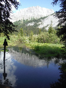
Out house at trail head, map signage just after trail head. I do not remember any other of these signs on the trail, so pay attention.

sign post with map of region, only one seen on this hike at the trail head.

Book reference : Gillean Daffern's KANANASKIS COUNTRY trail guide - Vol 1 3rd Ed. is a good reference, black and white pictures, decent topo maps in the back. The Map itself is 82j14;

Start on the mud lake parking, setting out on the built up service access road going West past the South side of Mud lake and over the muddy stream flowing through the culvert under the trail. There is a pretty serious grate covering the culvert.

Mud Lake
Mud Lake

The trail itself starts off as an old logging road.

The trail at the start... Very heavily used, I think by park vehicles at times too
Well travelled, do not take the first trail on the left around Mud lake, but then stay to the left at the fork, or you will go up French creek ( see http://www.trailcafe.com/hiking/individual/french_creek.html ). Right now that trail is signed as closed.

Initially the trail is reasonably strait and an easy climb. It is very obvious. It is an old logging road. It is not too exciting along this section. It is a typical walk through the pine forest.

Lots of yellow daisies, the odd purple one with the bright red of fire weed here and there. Lots of the other flowers and brush, but mostly the trees them selves.

To the right (North) is Burstall creek, it is often heard but only seen at times.

Burstall Lake (the first one I think).
At about the 2km point, there is an optional detour to the right which leads to the first Burstall lake, which we of course take. The short side trip not only gets you to the lake, but the first good view of Commonwealth peak on this trail. I'm mildly surprised to not find any path along the side of the lake. At least not off to the west in the same direction of travel as the trail. There is a bit of a path but it quickly peters out. We end up bush whacking a short distance back to the main trail. At the cost of a few scratches on the legs.

The recent trail maintenance has resulted in a large blown down tree being cut up with the logs for sitting on moved to a small clear area surrounded by a few trees, making a nice stop for the first rest and snack on the hike.

Shortly after is a cement bike rack. ( looks like a bit of a tire. Bender) , and the logging road transitions to a proper trail, with the prerequisite tree roots, and drops to avoid. It is still a very well travelled trail. It also has sections which are a bit more steep now.

Section of streams:

After leveling out for a bit the trail leaves the forest and enters the flat alluvial plain Above the Burstall lakes, today there are lots of small streams spitting and rejoining. Much of the source of the streams are from the glacier between Mount Robertson and Mount Sir Douglas / Whistling rock in the valley on the left.

There are other hikers on this section, they ask if we brought some water shoes. Some of the streams are easily jumped, some have "bridges" (small log other hikers have laid across). Today it is possible for an adult to get across without soaking a shoe, but not easy. For an eight year old it is impossible, nor even desired. This was her favorite part of the trip, successfully crossing all stream, whether, by bridge, jump, or stomping strait through. The 12 year old liked it too, but because she enjoyed the challenge of staying dry.

This section goes on for a few 100m or so. With sign posts marking the trail. Although they are easy to miss a bit hidden by the tall scrub trees which grow through out this section. It is in this section that you first get really good views of the mountains around the pass. Prior to this the hiker is rewarded only with partial glimpses ( except at the lower lake)

looking back just exiting the stream section, looking at Birdwood Mountain(?)
The sign post at the far side of this section is surrounded by water, we are able to almost stay dry by going up stream 20 or so meters.

Trail after the braided stream section
Now back in the trees the trail again begins a steeper climb, once again through a forest of pine trees.

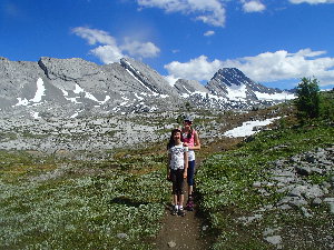
Flat through the upper plateaux. Here there are some great views of the peaks surrounding the upper parts of the valley. A km or so of flat trail allows for a bit of a walking rest. The trail transitions from heading mostly West to South in this section. With the late start today, It makes for good light in capturing the solid rock wall extending North from Mount Sir Douglas on the East side of the upper valley, which dominates the view on this section, although looking back down the trail the Mount Bridwood to the North is very impressive.

Next climb section:

Another picture of Birdwood
Once again you enter the trees, this time there are patches of snow here and there. The tree are in general less dense, and now a bit smaller. After a while the trail begins to climb and turn west as it runs up the side of the ridge ??? (not named on 082J14). There are to fairly long traverse sections on this trail, taking you near the tree line, before it starts to run a bit North.

Mount Douglas (I think) marked on one map as Whistling rock
There are much larger snow pack areas now (in July), in parts covering the trail. Tempting to start a snowball fight. The trail itself remains dry until it starts to run Northwards; On this day the trail had crossed an outcrop of slushy snow for 20 or so meters in two places.

we've gone over the ridge here (again looking back)  trail still obvious, but smaller than the virtual road at the start
we've gone over the ridge here (again looking back) trail still obvious, but smaller than the virtual road at the start
Across the divide , briefly into Banff. That is what the sign says. The sign also states and hat all park regulations apply, and that you need a pass to be here. So don't forget it just in case.

Continuing into Banff park itself, the trail again runs West. it ends up skirting a large depression, which is mildly interesting in that there is no water captured within it. Apparently these depressions mark the head of an old glacier, or so I've read once. The actual trail as shown on the map runs down into the valley, however stay leftward on the most traveled part of this trail to get to the view point.

The view at our lunch point, and turnaround.  Looking out over Spray Valley, with Leman lake in the distance
The view at our lunch point, and turnaround. Looking out over Spray Valley, with Leman lake in the distance
A few hundred meters later, up and over a final bluff you come to the lookout into Spray river valley. Off in the distance is Leman lake, a very small mountain lake. Although this is a pass it is a fairly high one the view is pretty awesome. The girls don't seem to impressed, they liked the views earlier better.

It is high enough up, and windy enough to make it fairly cool. Since we were out late, a quick lunch and we are off on the return trip.


Gallery

kt_DSCF1662.JPG

Mtn Goats on the way up

kt_DSCF1666.JPG

sign post with map of region, only one seen on this hike at the trail head.

kt_DSCF1667.JPG

Mud Lake

kt_P1010788.JPG

The trail at the start... Very heavily used, I think by park vehicles at times too

kt_P1010790.JPG

Trail a short distance in (less than 2km). Dragging the kids along on this one.

kt_P1010792_-_P1010795.tif

Burstall Lake (the first one I think).

kt_P1010797.JPG

Entering the section of braided streams

kt_P1010800.JPG

Checking out stream at the first bridged crossing.

kt_P1010801_-_P1010807.tif

Looking back towards the Burstall lakes, and commonwealth peak

kt_P1010811.JPG

jumping one of the streams

kt_P1010817.JPG

being careful... in her defense, the water is deep enough that you can's see the bottom, could be 6" or 2'

kt_P1010815.JPG

Mighty Falls? That's not in the guide book

kt_P1010814.JPG

Another view of the Mighty falls

kt_DSCF1681.JPG

looking back just exiting the stream section, looking at Birdwood Mountain(?)

kt_P1010823.JPG

Trail after the braided stream section

kt_P1010824.JPG

Burstall Creek

kt_DSCF1683.JPG

fire weed (I think that is what it is called)

kt_DSCF1685.JPG

Mount Birdwood

kt_P1010831.JPG

flatter section after the clib from the braided streams

kt_P1010832_-_P1010838-II_blended_fused.tif

Panorama (so a bit distorted) Birdwood on the left, Commonwealth peak in the distant center, with the valley we just walked through, and the spur/ridge coming of the North side of Mount Douglas

kt_P1010839.JPG

Another picture of Birdwood

kt_P1010840_-_P1010842.tif

Mount Douglas (I think) marked on one map as Whistling rock

kt_DSCF1688.JPG

Again looking back the way we came

kt_P1010851.JPG

looking back, very close to the top of the ridge... nearly at the treeline.

kt_P1010843.JPG

we've gone over the ridge here (again looking back) trail still obvious, but smaller than the virtual road at the start

kt_P1010845_-_P1010847.tif

The view at our lunch point, and turnaround. Looking out over Spray Valley, with Leman lake in the distance


Content Copyright © M. Tanton 2015


Back to TrailCafe: Hiking Back to TrailCafe: Main page