Hike: Pocahontas
Quick Summary
Difficulty: Moderate (but short)
Distance: 5-8 Km
Elevation gain:____
Time Taken: Aprox 4 hours.
Cool points: Some pretty cool scrambling/bouldering
on this hike.
If ever there was a 'guaranteed' hike to see animals on this is
it (sheep or elk), due to the Salt lick at the start of the
hike.
What it's Not: There is not much of a trail, it is not
a regular hike.There is a trail to start, but you end up striking
out on your own.
Date of Hike: 1991,1993
Recommendations: On a hot day, this is a good
morning Hike, or on a cool day take it in the afternoon
Notes: This is a good half day hike
if you are arriving in Jasper in the afternoon vi Hwy 16
Also the real name of Pocahontas is Roche Miette. The Map is
put together years later, and is not accurate. Boldering was
requried.
|
|
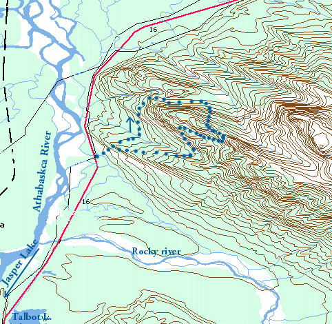
How to get to the trail head
The trail head for this hike is right off Hwy 16. Coming in from Edmonton,
the trail head is just a couple of miles past the Pocahontas cabins.
Ramble on about the hike
These hikes were along time ago... so the memory is a bit vague at the time
of this writing. I call this hike Pocahontas, but that is just my name
for it. The nearby cabins are named Pocahontas, and the mountain next to
them is Roche Miette, This mountain looks like the profile of an Indian
looking up into the sky, complete with head dress. This makes Roche Miette
one of the most striking mountains as you enter Jasper National Park from
the East on Hwy 16 (the Yellow-head trail).
We chose this hike as were were driving into Jasper Saturday afternoon,
it was already quite late, around 2 or 3:00. We set up camp in the
Snaring Creek overflow campground (the 'real' campsites were full),
which seemed like a very nice place for camping we were pretty happy at the
time that the other sites were full. Unfortunately there is a train track
about 25 meters from where we setup camp!!, we did not find out until
later in the day after being tired out from out hike, that a train when
rumbling by as we were settling down for the night.
The hike starts right from the highway, I am not sure if you
can make it to the top from this side of the mountain, but
that was not our intent at the time. Our goal was the top of a spur called
Syncline Ridge, off the
side of Roche Miette. You start up the west side of Roche Miette mountain, on a
small gravel path, after about a km or so of the winding trail meandering
on the more or less open Roche face. The trail just sort of vanishes, I
think it is more a combination of the animal paths that come down at this
point on the mountain. You end up walking up a medium incline on the
surface of bare rock. There is not much in the way of protection fromm
the sun, so It is probably a good Idea to have you sun screen on
this hike, even if you are like me and hate the slimy goop.
I pretty vividly remember a scene where a dry creek bed is eroded into the
bed rock of the mountain, the climb to the top of this point is still
fairly steep but quite easy. Our trail then veered to the North of the
knoll so that we could approach from that side. It is here that
I have my first memory of self infliced fear in the mountains.
The North side of the
hill turned out to me quite a bit of a scramble, in moderate to light trees.
So there is lots to grab on to as you ascend strait up for 10 feet or so,
then come to a 2 ft ledge, and then up another steep section. This goes
on for probably 300 meters or so. At one point I decided to go strait up
a rock face, about 15 feet, I could have easily gone around it, but
choose instead the more challenging route. At one point I was standing
about 10 ft up the face, with one foot on a 2 inch ledge,
with good hand holds, but my other foot
just could not stretch to the next small ledge, only short by about 3 or
5 inches. So I jumped....(pretty stupid). As I pushed off my bottom i
foot slipped,
Of course I was able to hang on, but It took a good 5 minutes for my heart
to slow to below 100 beats per minute. After that for some reason, my
leg had no trouble at all stretching up to the next ledge
After getting to the top of my boulder, I immediately stopped for lunch.
Not much further up we came to the more level portion of the spur, it
was quit heavily treed. We found a cave up here, It was pretty cool, but
we left it for the next time we came back to actually explore it a bit.
Not much sticks out in my mind about this hike, We continued over the
top of the spur. From here we had a good view of the Athabaska river and
the rest of the valley, including Highway 16 into Jasper, we were
up fairly high, but the peaks around us made it feel as if we had
only taken the first few steps on the complete hike.
It looked like we could have made it along the
ridge quite a bit higher, but the day was nearing the end, and we started
down the south side of the spur. This route quickly proves to be
a very difficult climb down. To much for our group, so we followed
the ridge back along the west side to the easier descent at the
north west slope of the spur
Lessons Learned on this trip.
- Do NOT take stupid Risks. If I had fallen there would have been
serious consequences. Although the first fall would have been maybe
15 feet, I am pretty sure I would have continued down half a dozen
similar drops, as I careened off the side of the mountain.
- Bring a Camera (I wish I would actually remember this one), Actually
I distinctly remember having pictures of this hike, I just seem to
have lost them. I'll get them up if I find them.
[an error occurred while processing this directive]

