Hike: Mount. Temple
Quick Summary
Difficulty: Easy-Moderate (long) SCRAMBLE
Distance: (?)
Elevation gain: (?)
Time Taken: 5hrs to top, 9 total
Cool points: almost every thing
What it's Not:
Date of Hike: Sept 30, 2002
Recommendations:bring some warm cloths
Notes: requires 6 people to
help prevent Grizzly bear encounters.
|
"Map is © Her Majesty the Queen in Right of Canada,
Department of Natural Resources. All rights reserved."
map from the website
http://toporama.cits.rncan.gc.ca/toporama_en.html
|
How to get to the trail head
The Trail head is at the Moraine Lake Lodge. Take Hwy 1
from Calgary to Lake Louise, turn in to Lake Louise, follow the road
out to the south side of the 'town site'. follow this road towards the
actual lake, you will have to turn to the left prior to Lake Louise,
towards Moraine lake.
Ramble on about the hike
First off, a quick tip, I recomend using the bathroom facilities
at the lake louise tourist stop site, prior to heading out to the
trail. The facilites there are quite a bit nicer, than the pubilic
ones out at Moraine lake.
This was my second hike of the season, it was a bit more than
I was ready for physically. I hurt for almost a week after wards.
Even so this hike was worth it.
My buddy Richard, had tried to get me to go hiking two weeks
before. He wanted me to go to Mt. Robson. Alas, My back is
wounded from summer hockey and there is no way I can carry
a back pack with 3 days of gear. The next weekend he wanted to
do the temple day hike. This is described as the 4th highest
peak in the southern rockies. Once again I jammed out, and
in fact the trip was cancelled, as a minimum of 6 people are
required to do this hike. After showing me the pictures of
the Mt. Robson hike, he asked me to do temple again. This of course
is pretty motivating. My back was slowly getting better, not
100% but I said I'd give it a try.
The trail head to Mt. Temple is next to the Moraine Lake lodge.
This is around a 3 hour drive from Calgary, so we stared the
day bright and early at 6:30 we were leaving Calgary. (That's
early for me now-a-days). We arrived at the Lake Louise
complex just off the highway, used the facilities, got a snack
and drove to the trail head.
I've got some new toys for this hike. The first thing is a
camel back, this is basically a water pouch you carry in a
back pack, with a hose that clips on to the front straps.
De-clip the hose and you can drink without digging up a
water bottle.
I actually bought it for biking, however it works well
enough for day hikes, hold 2 liters of water. The second
toy I got was a set of hiking poles, these I decided were
required if I was going to have any hope of getting my old
back up the hill.
On arival at the parking lot, and unpacking my gear,
I found the camel
back was empty and the 2 liters of water had spilled all over
the trunk of the car. ugh, not a great start. I had put the
pack itself on the end of the water spout, and it syphoned out.
After a stop in the lodge caffeteria, where the filled up my
camel back we were on the trail at 9:00 or so.
Moraine Lake
Moraine Lake must be the bluest lake I've ever seen. It is
small, and up tight on the south side against the (either 7
sisters, or the 10 peaks?). You can come up and stay at the
lodge here, or rent a canoe for $25 an hour and go paddle
around the lake.
The trail to the Temple scramble starts out behind the
Moraine lake lodge. Start off following the trail that
runs around the lake and take the right fork just after the lodge.
In our case the trail is marked with a sign saying that
by Law you must have 6 people on the trail due to Grizzly
bear activity in the region. I understand that this is not
always the case, that typically it is a recomendation in the
spring, and law by fall.
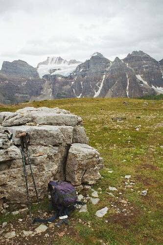
The Trail up to Larch Valley
The first portion of the trail is a very well maintained
trail indeed, it follows up beside the lake traversing the
hill side to an upper platau. For the most part you are in
the trees, but get occasional glimpses of the lake, and the
mountains on the far side of it. This portion of the hike
is a fairly easy, and would be worth the stop if you happend
to be driving through the area. There is a bench or two along
the way where you can stop, enjoy the view, and catch your
breath.
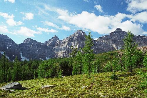
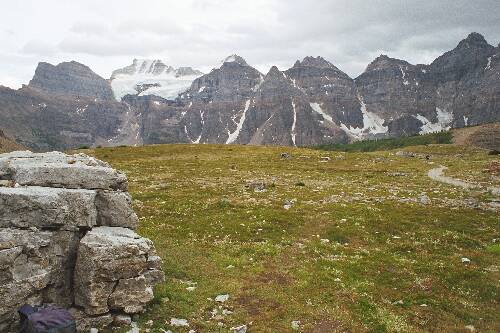
larch valley

At least I think that is what the name of the valley
is.
this is an area full of Tamarack trees. With a
bit of an open marshy grass land area. With the open view
of the valley of the 10 peaks on one side, ____ and Mt. Temple
on the other side, this would make a fantastic photo shoot for
a wedding or any such thing (although I'm not sure this would
be permitted due to the fragile nature of the upper grasslands).
In the fall I'll bet it is stunning up here, I'll make an effort
to be back in a month or so to check it out.
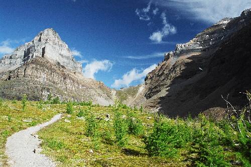
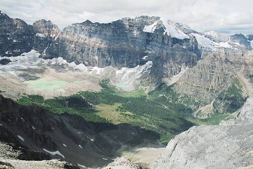
The Trail to Sentinel Pass

The next portion of the is a slow transition for larch
valley to a true upper medow. complete with two tarns. The
trail takes you North between Mt. Temple, and Mt. ____
towards Paradise valley on the other side of Sentinel Pass.
You will come to a waiting point, with a bench sitting just prior
to the upper medow. A good place for a rest. During the times
of the year where you are not required to have 6 people in your
group to get to this point, this serves as a place to wait
and join another group if you do not have 6 in yours.
The trail continues towards Sentinel pass, which is in plain
veiw. The trail comes to an upper tarn (a small upper lake) then
runs beside it to the pass. At this point the amount of work in
the maintenance of the trail ends. The trail is still very good,
just that is is the end of the point that seems to be maintained
by the lodge, parks service, or who ever maintains the trail .
I used to dislike these maintained trails, they seemed so unatural
to me. However I've changed my opinion on them recently, A maintained
trail helps keep people on the trail, and off the high altitude plants.
The upper valley is nice and flat, at the end of which, skirts
the edge of the valley just on the side of Mt. Temple, it the comes
to the furthest north edge of the valley, it looks like a steep
wall from inside the valley, kind of odd. The trail
traverses up this final step portion and brings you to the top
of Sentinel pass.
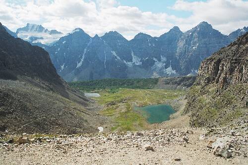
Sentinel pass

We took a short break at the top of the pass, had a bit to eat.
While up there, the ground Squirrels (aka, Chipmunks?). were
obviously used to humans. Two of them came running to us, and were
in a bit of a battle with each other to try and get some crumbs
of food. Pretty cute, when no one was looking one ended up inside
a back pack... jumped out just as we were leaving.

It is pretty obvious why this is called Sentinel pass. The
Sentinels are hoodoo like structures that are present in the pass.
They are pretty cool, Veritcal spires the run up to the sky. I
did not have my camera, but every else did. I'm sure we have
several picures of one or two of them. The pass looks down to the
North onto
paradise valley (and the trail continues down to it). you can see
the lakes and mountains surounding that valley.
Up until this point the hike has been a moderate in difficulty,
a few steep spots, but the trail is well maintained,and not
difficult. In my opinion, running shoes would be good enough
to make it to this point. Now the scramble begins up Temple
Mountain.
Temple Mountain - the scramble
From this point on we are in scramble mode. Although there
are a few points that are a bit tricky, I'd have to say that
this is a fairly easy scramble. This contradicts the guide
book we had, which rates it as a moderate scramble. It is
however fairly long, or it seemed that way to me, which would
increase the difficulty.
From Sentinel Pass, you travel to the East, up the side of
Temple, for
a ways before comming to the first real obsicle that is more
than a few meters high. According to the book there
are basically three routes up the first section. We could see
several groups already working thier way up the hill. Our group
split up here, three of us chose
to take what was the easiest route up the hill. That being the
third chute up. To get there follow the trail past a wide chute,
then past what is almost a narrow chimny, and then take the next
way up.
The other 4 in our group were a bit ahead of us at this point, we
did not meet up with them until we stopped for lunch about 45minutes
later. From here we followed southwards along the face of temple. there
is now a much larger wall to be scrambled up. (other folks do go
strait up). For us we followed along about 1/2 through the
'ampetheater' and found a fairly easy way up there. The trail was
almost non-exsistant at this point, it looked like we were following
maybe 2 or 3 tracks through the scree. So it seems most people go
up earlier. We then had to double back to the ridge that goes up
from Sentinel pass.
Once back at the ridge, a short easy scramble brought us to
the rest of the group, and about a dozen other people. I was surprised
to find a team mate from my hockey team in the group of other hikers on
the trail. Small world. We stopped for lunch, enjoying the view of
Paradise Valley, and the Valley of the 10 peaks.

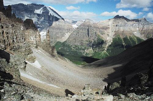
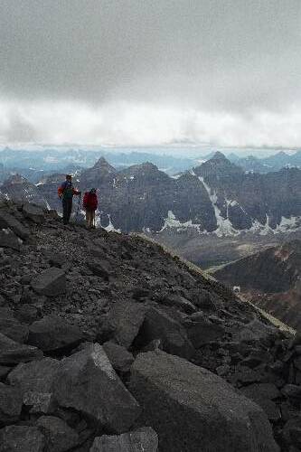
After lunch we went a bit south and scrambled up the next section,
about 20 meters or so, and came back to the ridge. At this point we
had a very nice view off a ledge. Took several pictures, but none
really show the ledge we are out standing on very well.
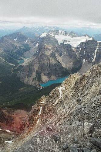
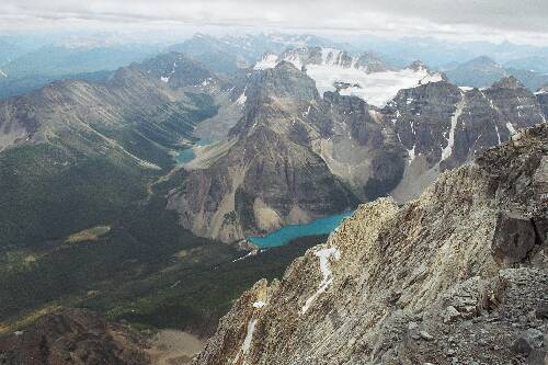
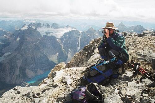
Below are some pictures looking down into paradise valley from
the ridge, and then of Rich and Mark sitting infrom of the
valley of the 10 peaks.


After the pictures, Rich, Mark, and Bill had already headed on
up. They wanted to ensure they got to the top before any weather
blew in. The remaining 4 of us trundled along in a lose group
up the next scramble section. Sean an I took off a bit of the
other two. Once passed this next easy scramble section, you end up
on the sloped side of temple. From here you can more or less see
clear to the peak. Lots of people were up in front of us, maybe 25
or so, it looked really crowded. Sean and I were travelling at
different paces, so we ended up ariving at the top apart. This
next section is a basic trudge up to the peak. If you stay near the
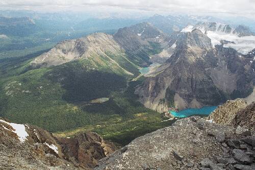
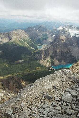
ridge you will get very nice views down into the Moraine lake valley.
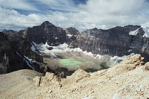
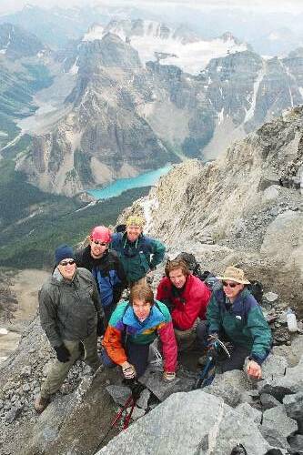
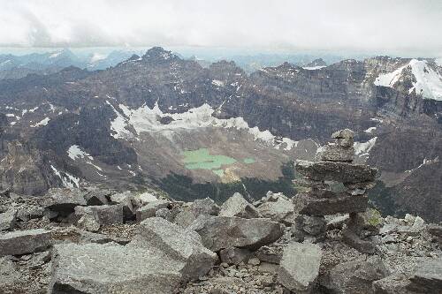
The top
At the top you do get a fantastic view, however the view has been
fantastic for quite a while on the way up. There is a bit of snow up here,
but the peak it self is barren. The snow is off on the east side of the
peak. One interesting thing is you can see back down to the
brilliant blue of Moraine lake way down below at the trail head. From
up here you really feel high, you tower above all the mountains
to the south, east and north. To the west there are some that look
to be a similar hight.
After about 1 minute of no exsertion, you quickly cool off. It was
22 degrees at the trail head in the parking lot, it is 2 Degrees up
here, and fairly windy. I
put on my fleese pull over and gloves on earlier. Now it was time
for the pants and wind breaker as well. We stayed up there for quite
a while, maybe 45 minutes. I'm not sure when Kevin, and Glen arrived,
but it as maybe 5-10 minutes after I got there. Rich and the others
were up before me.
We took pictures, ate some more, chatted with the other folks that
were up there. The only bad thing was the cold wind, at 2 Deg C without
wind chill I was a little unconfortable. It really
helped sitting behind a small ledge up on the top to get out of the
wind for warmth. That and the weather
was starting to get a bit onimous. I'm not sure if it was a couple
cracks of thunder that we heard, or glaciers braking loose. But it
was somthing to give us pause. It never did rain (or snow).
One neat weather effect that stuck in my mind from this trip
was watching the clouds which where about
eye level out accross the valley, come floating in towards Temple, and
then be diverted up and over us, just as they came to temple. The wind
at the level of the clouds was blowing strait at the face and went
up over the mountain, rather than around it.


The Decent
Comming down is usually alot faster than going up for me. But
I was tired. The legs were becoming spagetti. The long slope from
the peak down to the scramble portions was not to bad, and we covered
it quickly. Once we got to the scramble areas, we slowed down, and made
our way down. Again our group split up, Rich and Mark wanted to
try the more techincal decent closer to the ridge. Bill, Kevin,
Glen and myself decided to take the same way down that we came up.
Once we got to the easy route, we made a bit of a mistake (in my
opinion). Instead of traversing back to the ridge, and comming down
the trail on Sentinel pass, we went more or less strait down the
amptheater. This worked out well enough, The scree was really fast.
however once at the bottom we had to work through a rock field, full
of 10-20 inch in diameter rocks. I did not care for picking each
individual foot placment. I just
wanted a nice smooth trail, as my legs were exhausted at this point.
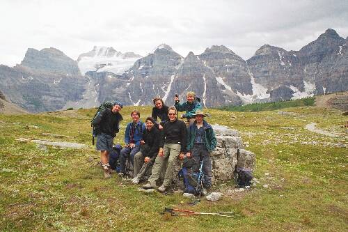
Kevin and I were the last to make it down to the Tarn lake area,
we had another break. Took some more photos of the group sitting
around a large rock in the middle of the upper medow.


The rest of the trip back to the lodge was fast and uneventfull.
Concluding remarks
This is the best and nices hike I've been on in quite some time,
if not the best. I highly recommend it. However for us the weather
was good, and had been good for a while, the trail was mostly
free of snow, and as such was fairly easy.
[an error occurred while processing this directive]